Wednesday, January 28, 2009
Fashion Show Fun
Shot my first fashion show this past Saturday night in Denver. Check my site soon for a new portfolio from the show.
Saturday, January 24, 2009
Denver days
Thursday, January 22, 2009
Wednesday, January 21, 2009
Catalog Cover
Declare, from the makers of Jett MTB, is coming out with a new team/shop line of apparel. Check out the cover featuring one of my photos of a Mafia rider.
Friday, January 16, 2009
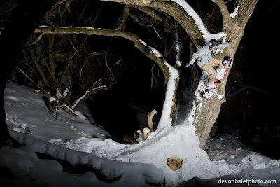
Go climb a tree!
Kaelin Bamford high tree flying in Glenwood Springs CO. Special thanks to Zach with Bern Helmets for supporting the dome protection!
New winter images
Started off the new year with a big stobe pop! Met with my buddy Kaelin Bamford and spent a full day of building, riding and shooting. we came away with two great images that i posted on my site. check it out here.
Tuesday, January 13, 2009
Surf report showing bad snow forcast
Check this link. A good site to check up on your favorite surf spot and a good way to predict weather to come. All the lame off shore winds is making for less than desirable snowfall in CO the past few days.
Wednesday, January 7, 2009
A word from our snowpack
Aspen area report from CAIC:
Anywhere from 1-5” of low density new snow has fallen around the Aspen zone in the last 24 hours. This storm also brought some strong W and NW winds to the area overnight that will be transporting all that light snow onto lee aspects and creating some tender new slabs in the backcountry today. Those stronger winds look like they will stay with us throughout the day today. Look for these slabs to have formed on slopes facing NE-E-SE near and above treeline. Although the forecast is calling for some light snow totals today, keep an eye out for locally higher amounts in the area you are traveling. The moist NW flow over the state sometimes favors portions of the zone with heavier snow, especially in the area near the Highlands Ridge, Richmond Ridge, and Ashcroft. The last few days have seen light snow and some stronger winds at higher elevations. The upper snowpack now has a few layers of wind slabs that will be a concern for both triggered and natural avalanche activity.
Fresh winds slabs in the upper snowpack will be the primary concern for avalanche activity today, however there are a few other layers to be concerned with as well. Near and below treeline, underneath the last few days’ worth of storm snow, you can find a layer of surface hoar and some small facets. Observers found surface hoar on all aspects near and below treeline except the SE-S-SW facing slopes prior to last weekend’s storm. On the northerly aspects the surface hoar layer was over an inch thick in sheltered pockets. Surface hoar is a very reactive weak layer and fractures can propagate very long distances. Conditions could become very touchy as winds drift and slab the new snow. Slopes near treeline could be the most problematic. Thoroughly check for the presence of surface hoar or facets before you commit to any steeper slopes.
Finally, there are still those weak layers near the base of the snowpack to think about. Over the last couple weeks the middle of the snowpack has become quite a bit stronger making avalanches harder to trigger on these deep, basal weak layers. Although harder to trigger, it is not impossible and finding the right trigger point on a slope could result in a destructive deep slab avalanche. If you are traveling on slopes facing NW-N-NE-E at all elevations, you should be thinking about deep slab avalanches. Your snowpack observations should include a look near the ground for the presence of these problem layers. A conservative choice of terrain is still a wise idea in the backcountry.
Be safe out there. Get your face shots but always make sure to make it home.
Sunday, January 4, 2009
Thursday, January 1, 2009
Bellwether 09 site is live
The images from my shoot back in September are now live on the Bellwether site. Click here to see.
Another year, but not just any day.
I spent the last night, like many others, celebrating the new year. A crew of friends celebrated the strike of midnight high above Doc Holiday's grave sledding down the mountain. only minor injuries were reported, and surely many hurting heads for the morning. I got up early and spent a full day of shoveling, scouting, building, shooting and general mayhem. Myself and my friend Kaelin spent the whole day with one mission in mind.... Get some sick photos of urban jibs. And that is exactly what we did! Check back soon for photos.
Subscribe to:
Posts (Atom)